Welcome to the SLATS 2055 Long Range Transportation Plan Update!
Why is the LRTP Important?
What is a LRTP?
The Long Range Transportation Plan (LRTP) is a federally required planning document that every Metropolitan Planning Organization (MPO) must update regularly – within the SLATS region the LRTP must be updated every five years. The LRTP serves as the region’s roadmap for meeting long-term transportation needs and complying with federal regulations that guide how funds can be spent on transportation projects.
The LRTP evaluates current and future conditions, identifies key challenges and opportunities, and prioritizes investments across all modes—including roads, transit, walking, biking, and freight movement. The plan supports the regional transportation network remaining efficient, resilient, and aligned with the community’s long-term vision and goals while supporting eligibility for federal transportation funding.
SLATS Study Area
The LRTP covers the entire region served by SLATS, the federally designated Metropolitan Planning Organization (MPO) for the Beloit urbanized area. The SLATS Metropolitan Planning Area spans the Wisconsin–Illinois state line and includes portions of Rock County, Wisconsin, and Winnebago County, Illinois. Within this boundary, the MPO includes the following municipalities and jurisdictions:
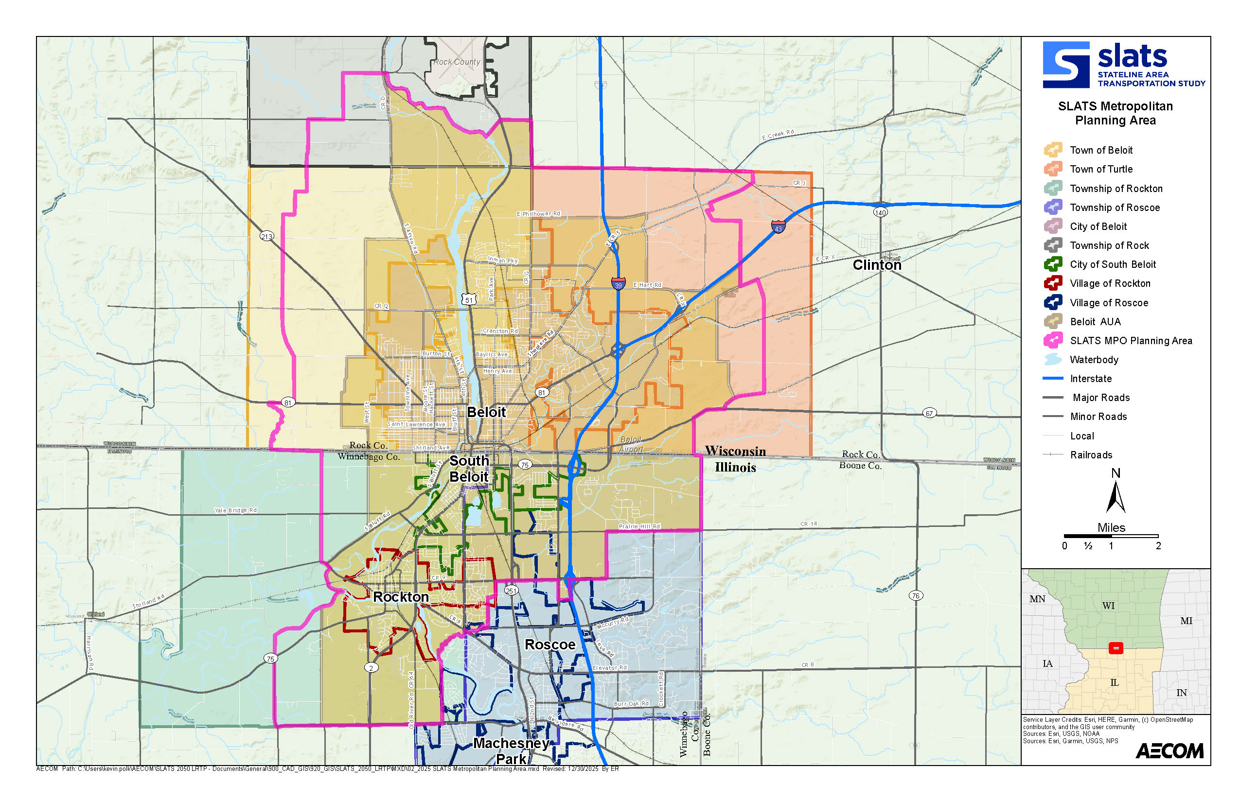
This diverse region contains a mix of urban centers, established neighborhoods, major employment corridors, and rural areas. Understanding the geography, demographics, and travel patterns across these interconnected communities is essential to developing an effective long-range transportation strategy that supports mobility, economic vitality, and quality of life throughout the Stateline area.
LRTP Timeline
The LRTP update began in late 2025 and will continue through Fall 2026. Throughout this process, the project team will meet regularly with the SLATS Technical and Policy Committees to review existing conditions, future-year forecasts, project needs, fiscal constraint development, and environmental and mitigation considerations. Public and stakeholder engagement will also occur at key milestones. Please visit the Events page for the most current information on LRTP outreach activities.
A Preliminary Draft LRTP will be shared with SLATS staff for review in Summer 2026, followed by distribution of the Draft LRTP to SLATS Committees and a required 30 day public review period. Following consideration of public and committee feedback, the project team will develop the Final LRTP and present it to the SLATS Policy Board. The Board must adopt the plan no later than October 4, 2026, to maintain federal compliance and support the continuation of the MPO’s long-range planning responsibilities. Once adopted, the Final LRTP will be posted for public access and will serve as the official document for regional transportation investments through 2055.
More Information on SLATS
The Stateline Area Transportation Study (SLATS) is the federally designated Metropolitan Planning Organization (MPO) for the Beloit urbanized area. Established in 1974, SLATS is responsible for carrying out the federally mandated 3‑C planning process—continuing, cooperative, and comprehensive transportation planning for urbanized areas with populations over 50,000. SLATS spans the Wisconsin–Illinois border and includes jurisdictions in both Rock County, Wisconsin, and Winnebago County, Illinois.
SLATS coordinates regional transportation planning, ensures federal requirements are met, and prepares key documents. In addition to preparing the Long Range Transportation Plan (LRTP), SLATS prepares other documents such as the Transportation Improvement Program (TIP), and the Unified Work Program (UWP). These plans guide how transportation dollars are invested within the region.
Communities Within the SLATS MPO Boundary
Based on Census-defined urbanized areas and MPO boundary designations, SLATS includes the following municipalities and jurisdictions:
The SLATS Metropolitan Planning Area covers over 100 square miles and supports a population of just over 63,000 residents, with approximately 70% living in Wisconsin and 30% in Illinois.
SLATS Committees
Policy Board
The SLATS Policy Board serves as the MPO’s decision-making body and is responsible for the adoption of major transportation planning documents, including the LRTP and TIP. Member agencies represented on the Policy Board include the municipalities and jurisdictions listed above as well as the Wisconsin Department of Transportation (WisDOT) and the Illinois Department of Transportation (IDOT).
Technical Advisory Committee (TAC)
The TAC provides professional guidance and technical recommendations to the Policy Board. The TAC evaluates data, analyzes proposed projects, and reviews planning documents before they advance to the Policy Board for approval. Membership includes:
- Public works officials
- Municipal engineers and planners
- County planning/transportation staff
- Local public transit representatives from Beloit Transit System (BTS) and Stateline Mass Transit District (SMTD)
- Additional non‑voting members include FHWA, FTA, WisDOT, IDOT, and adjacent MPOs (Rockford MPO and Janesville MPO).
Learn More About SLATS
More detailed information on SLATS, its planning responsibilities, past plans, and committee structure can be found on the official MPO webpage.


